Brits are set to be pounded by a 600-mile wall of snow over the coming days from a -10C Scandinavian freeze.
Weather maps show up to 200cm (78 inches) of snow falling in some areas along with widespread flurries in a cold snap that is expected to last into the second week of December. New maps from WX Charts show London, Birmingham, Sheffield and Leeds all in for a covering of up to 100cm, with most of England and Scotland set to be affected by flurries in a 600 mile wall of snow and the mercury could dip as low as -10C.
The deepest snow will be seen in the Scottish Highlands, where snow could be as deep as 200cm, with Glasgow and Edinburgh seeing a lighter covering. The Met Office said: “There will be widespread overnight frosts for much of the UK in the coming days and a risk of snow for some regions.
"Much colder conditions are expected to affect the UK for the rest of this week and into the weekend, with daytime temperatures rooted in single figures and overnight temperatures falling well below freezing in many places. With the UK sitting in cold air from Scandinavia the weather is turning much colder for the rest of this week and the start of next with daytime temperatures struggling to get above single figures and overnight temperatures staying below freezing for much of the country.”
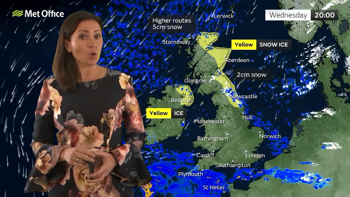
The Met Office has yellow warnings for snow and ice that cover most of eastern parts of the UK and a large section of northern England which run until Friday. There are also alerts for areas of the south west of England and an ice warning for Northern Ireland.
Met Office Chief Meteorologist, Neil Armstrong, said: “We’ve already seen snow settling in parts of eastern Scotland and northeastern England. As the cold air continues to spread across the UK we also expect to see some snow over the high ground of southwest England overnight tonight and through tomorrow.
“Snow showers will continue along the North Sea coast with a northeasterly air flow, leading to further accumulations over higher ground. Where the showers fall as rain there is a risk of icy patches forming overnight with temperatures widely dipping below freezing. A number of National Severe Weather Warnings have been issued and these are likely to be updated through the week so stay up to date with the forecast for your area.”
UK weather forecast
Today:
Cloudy for southern counties of England, with further patchy rain at times, falling as snow across the hills in the southwest. Sunny elsewhere, with wintry showers towards coasts in the east. However most places remaining dry with sunny spells.
Tonight:
Many places dry with clear spells and a widespread frost developing. Wintry showers near North Sea coasts and parts of Northern Ireland. Freezing fog patches developing. Cloudier in the south.
Friday:
Staying cold Friday, with sunny spells and some wintry showers, mainly towards coastal areas. Another widespread overnight frost and some freezing fog patches likely.